Volcanoes and Other Igneous Activity summary
Volcanoes and Other Igneous Activity summary
The following texts are the property of their respective authors and we thank them for giving us the opportunity to share for free to students, teachers and users of the Web their texts will used only for illustrative educational and scientific purposes only.
The information of medicine and health contained in the site are of a general nature and purpose which is purely informative and for this reason may not replace in any case, the council of a doctor or a qualified entity legally to the profession.
Volcanoes and Other Igneous Activity summary
Notes on volcanoes
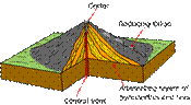
Definition of a volcano: an opening in the surface of the Earth through which magma erupts (as lava or pyroclastic fragments). A volcano is underlain by a magma chamber, a reservoir that stores magma before it rises as an eruption.
Not all volcanoes erupt lava; some erupt rock and magma fragments (pyroclasts); some erupt gases.
A common misconception is that magma exists everywhere beneath the surface, and seeps out wherever the surface is cracked, producing a volcano. This is not true.
Experiments have shown that if a significant (2%) of magma exists in the mantle, it will rises due to buoyancy and will eventually reach the surface as a volcano. All volcanoes are underlain by a source of magma, and all significant sources of magma produce volcanoes. Therefore the presence of a volcano implies melting, and the ABSENCE of volcanoes implies NO MELTING. To disprove the misconception you need only examine the distribution of volcanoes on Earth:
- Most volcanoes occur along the edges of continents, but not all continental edges have volcanoes. For example, the eastern margin of North America does not have volcanoes.
- Some volcanoes form island chains in the middle of the sea, for example the Aleutian chain of Alaska;
- There are some isolated volcanoes in the middle of continents or oceans, such as the Hawaiian islands (in the middle of the ocean), Yellowstone volcano (in the middle of a continent), or volcanoes in eastern Africa (i.e., Mt. Kilimanjaro).
- There is a continuous string of submarine volcanoes in the middle of the oceans.
This distribution can be interpreted in terms of plate tectonics. If you look at the distribution of the world’s volcanoes on a plate-tectonic map you can see:
- The volcanoes at the edges of continents occur above subduction zones. Continental margins without subduction zones do not have volcanoes;
- Volcanic island chains in the middle of the sea occur above subduction zones as well.
- The undersea volcanic chains correspond to the MORs.
- Some of the volcanoes in the middle of continents are due to continental rifts (again, a plate boundary) where a continent is being torn apart; for example, the east African volcanoes.
- The volcanoes that occur in the middle of plates, such as Hawaii, are called hot spot volcanoes, and are caused by anomalously warm mantle beneath them.
It is important to notice that most area on Earth do not have volcanoes! Therefore volcanoes are a relatively unusual feature on Earth, and it requires relatively unusual conditions to form them. The ‘normal’ state of the Earth is without volcanoes.
In order to understand the origin of volcanoes need to understand the origin of magma. Magma is molten rock, and may also contain some crystals or gas bubbles.
Magma does not melt like ice, wax, plastic, or other substances you may be familiar with. It does not melt at one temperature; it melts over a range of temperatures. With increasing temperature more and more liquid forms, until eventually the whole rock is converted to liquid. The range of temperatures at which both liquid and solid exist may be as much as 200°C.
There are essentially two melting temperatures for rocks. The first melting temperature is the solidus, which represents the temperature below which the composition is all solid. The second melting temperature is the liquidus, which is the temperature above which the composition is all liquid. Between the solidus and liquidus both liquid and solid coexist, in the amount of liquid increasing toward the liquidus.
You do not need to melt a rock entirely (to its solidus) to make magma. This is because small percentages of magma can escape from rock. So as soon as 2-3 % of a rock melts, the melt escapes, collects, pools, and forms a magma chamber. This small amount of melting is called a “partial melt”.
The magma rises and separates from the rock because it is less dense. For almost all substances (except water!) the liquid phase is less dense than the solid phase.
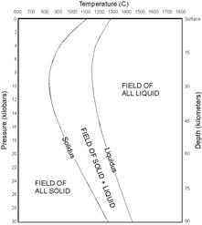
To understand how rock melts you use a phase diagram—a map that shows the stability of rock, liquid, and rock + liquid (conditions between the solidus and liquidus). Each point on this map (coordinate) corresponds to unique conditions of temperature and pressure. The phase diagram is constructed for mantle rock, the kind of rock that melts to produce nearly all magmas.
The conventional phase diagram has pressure increasing downwards, so it is situated like a slice of the Earth with depth (and pressure) increasing downward.
To know the state of the Earth (liquid vs. solid) you need to know the temperatures and pressures inside the Earth. This is the ‘normal’ geotherm; i.e., the geotherm at all those places on Earth that do not have volcanoes (which is most of them).
If you plot the ‘normal’ geotherm on the phase diagram for melting of mantle rock you can see that it lies everywhere in the field of “All solid”. This means that the Earth is entirely solid, without any magma. This proves the statement made earlier, that the ‘normal’ state of the Earth is without volcanoes.
The important conclusion is that there must be something special at the three places where volcanoes do occur: subduction zones, divergent plate boundaries, and hot spots—that causes melting.
If we revisit these three places we find that mantle rock is rising beneath both hot spots and dirvergent plate boundaries. Hot spots are defined by this rising plume of rock. At dirvergent boundaries, the upward flow of rock is induced, as the rock must rise to ‘fill in’ the gap produced when the plates spread apart. This is one of the special conditions that can cause rock to melt. The process is caused decompression melting, because the pressure decreases (“de-compression”) as the mantle rock rises.
It is essential to understand the difference between flowing rock and magma. The hot mantle rock beneath both hot spots and divergent boundaries flows, albeit very slowly. It is solid rock that can flow because it is so hot and under such great pressure. As this rock rise it melts, producing a second ‘fluid’—magma.
The mass of mantle that rises to produce decompression melting is very large—on the order of 100 km across. Heat flow into or out of this mass of rock is very slow, which keeps most of it at or near the temperature it had when it began to rise.
Consider a rock at normal temperature and pressure inside the Earth. Such a rock will plot on the geotherm. Now consider what happens when the rock begins to rise. As the rock rises its surroundings become progressively cooler, but it cannot lose heat fast enough to significantly change its temperature. Therefore the pressure on the rock decreases, but its temperature stays the same. On the phase diagram, this path is a vertical line pointing straight upward.
As the rock rises to the surface and the pressure decreases, the solidus and melting temperatures both decrease. Eventually the rock rises to the depth at which its temperature is the same as the solidus temperature. Any further rise will cause it to cross the solidus, and the rock will begin to melt. This is decompression melting. The melting zone for decompression melting is near the surface, and starts at the depth where the rising rock’s temperature equals the solidus temperature.
Decompression melting explains the primary origin of magma beneath volcanoes at divergent boundaries and hot spots.
Note that the temperature of the rock stays constant and its melting temperature (solidus) decreases during the process of decompression melting.
Once melt is formed, it will segregate and rise due to its low viscosity and high buoyancy. When it reaches the surface it produces a volcano.
The other location where volcanoes occur is above subduction zones. Here magma is produced by the process of hydration melting. The key feature of a subduction zone is the subducting plate, which carries into the mantle rock that formed on its surface.
 A process analogous to hydration melting is the melting of ice by salt, a trick used in northern climates to thaw ice on sidewalks and roads. Salt sprinkled on icy roads melts the ice by changing the chemical reaction from Ice à Water to Ice + Salt à Salty water, which occurs at approximately 5°F lower temperature. Thus if the temperature is 30°F, you can make ice melt by putting salt on it.
This process is an example of a process caused freezing point depression. It occurs when a contaminant is introduced that dissolves easily into the liquid phase but not into the solid phase. In the case of ice, the contaminant is salt.
In the case of mantle rock, the contaminant is water (steam). The melting reaction changes from:
Rock à Magma to Rock + Water à Hydrous magma.
Hydrous magma is simply magma with a lot of water dissolved in it. The addition of the contaminant (water) dramatically lowers the melting point of rock, and is an example of freezing point depression.
The changes to both melting points (solidus, liquidus) can be seen on the phase diagram. In the presence of water, mantle rock melts at over 200°C lower temperature than without water. The freezing point is depressed by over 200°C.
Melting triggered by water is called hydration melting. It occurs when rock at normal mantle temperature and pressure (i.e., on the normal geotherm) is invaded by water. This water is actually steam at the high temperatures and pressure in the mantle. The steam causes the solidus curve to shift to dramatically lower temperature, such that the rock now lies above the solidus. Thus it begins to melt.
The temperature, pressure, and location of the mantle rock does not change during hydration melting. Only the chemical environment changes—water is introduced.
The water that triggers melting is introduced into the mantle via the subducting plate, and is incorporated into the plate at the time the new crust forms at the MOR. The very center of the ridge at the MOR is underlain by the active magma chambers, which contain the magma that periodically erupts. This underground heat source creates a hydrothermal circulation system, whereby cold seawater sinks into the fractured rocks at the ridge, gets heated by the magma chamber, and then rises, exiting the seafloor in hot jets called black smokers.
The hot water circulating through the fractured rocks of the MOR alters them chemically. The water does two things: (a) it leaches certain chemicals out of the rocks, which then precipitate out when the water chills upon re-entry to the sea (making the jets “black”); and (b) it introduces water into the rock by changing the minerals into ‘hydrous’ minerals; i.e., minerals containing chemically bound water.
The most important reaction is one that converts olivine, one of the common minerals in the volcanic rocks of the MOR, into serpentine, a hydrous mineral:
Olivine + water à Serpentine
Serpentine contains bound water.
After the rock of the ocean floor moves away from the ridge all chemical reactions cease, and the serpentine remains in the rock.
When the oceanic plate reaches the subduction zone and starts to go down into the mantle it heats up. When it reaches a depth of about 100 km it becomes too hot for serpentine to be stable; it reverts back to olivine:
Serpentine à Olivine + Water
This is the water that rises and triggers melting in the mantle rock above the subducting plate.
It is important to understand that the subducting plate does not melt, and that the reason for melting is not heat produced by ‘friction’. These are two common misconceptions. The important role played by the subducting plate is to release water, which then triggers melting in the overlying mantle rock.
Heat transfer melting occurs when rock is heated until it melts (at constant pressure). In the Earth this process can only occur where there is a heat source, and the only possible heat source is magma. In other words, heat transfer melting can not occur on its own; it requires a source of magma (to serve as the heat source), and thus either decompression or hydration melting must precede heat-transfer melting.
As magma rises in the Earth it works its way through cracks and gaps. If the surrounding magma has the correct composition, the magma can cause it to partially melt. The partial melt then typically separates and mixes with the heat-transfer magma.
On the phase diagram heat transfer melting occurs as a horizontal line—constant pressure and increasing temperature, until the temperature crosses the solidus and the rock melts.
The composition of igneous magmas, lavas, and rocks can be classified into four major categories: ultramafic, mafic, intermediate, and silicic. The main properties of these categories are summarized in the table below, which should be memorized:
|
Ultramafic |
Mafic |
Intermediate |
Silicic |
wt% SiO2 |
40% |
50% |
60% |
70% |
Fe & Mg |
Lots ────────────────────────────────> Little |
|||
Na & K |
Little ────────────────────────────────> Lots |
|||
Temp. |
Hottest ──────────────−─────────────────> Coolest |
|||
Notice that the temperature is also correlated with the composition.
When a rock partially melts (i.e., at a temperature slightly above its solidus) it produces a magma one step more silicic than itself. In other words, the magma produced by a mafic rock is intermediate in composition.
The rock of the mantle that generates all magma by decompression and hydration melting is ultramafic, and is called peridotite. When this magma melts, by decompression or hydration melting, it produces mafic magma.
Heat transfer melting can only occur when a magma is hotter than the rock it contacts. Thus mafic magma can only melt intermediate or silicic rock.
Since intermediate rocks produces silicic magma when partially melted, and silicic rocks produce ‘ultra’-silicic magma when partially melted, heat-transfer melting can only produce silicic magma. Mixing this silicic magma into the heat-transfer magma makes it more silicic.
The two properties that contain how a volcano erupts are the viscosity and volatile content of its magma.
Volatiles are substances that are normally volatile at volcanic temperatures on the surface of the Earth—i.e., gases. The most important volatiles are H2O and CO2.
Viscosity refers to the ease with which a fluid flows; substances like water flow easily and have a low viscosity, in contrast to substances that flow sluggishly, like molasses, which have a high viscosity.
All magmas have a viscosity higher than molasses.
The viscosity of magma depends mostly on two things: its temperature and its composition. It also depends on the volatile content, but to a lesser degree than the other two.
Heating a fluid always decreases its viscosity. Since mafic magmas are hotter than silicic magmas, the effect of temperature alone would cause mafic magmas to have a lower viscosity (making them more runny).
Magmas with high SiO2 concentrations have higher viscosity. This is because in magmas and rocks Si always occurs chemically in the middle of a silicon tetrhahedron (SiO4)-4 molecule, which then are  variously linked together. Magmas with high concentrations of Si tend to have more and longer SiO4 chains, which get tangled up when the magma tries to flow—thus causing the viscosity to be high. Magmas with low concentrations of Si have fewer and shorter chains, which allow the magma to flow more easily without getting tangled; i.e., to have a lower viscosity.
Since silicic magmas have more Si than mafic magmas, the effect of composition alone causes silicic magmas to have a higher viscosity than mafic magmas.
Since the temperature effect and composition effect work in concert, the net result is that silicic magmas tend to be much more viscous than mafic magmas.
High volatile concentrations tend to decrease the viscosity of magma. This is because the volatiles bond to the silica tetrahedral and break up the chains. This effect is smaller than the other two.
To understand how viscosity and volatile content affect the style of eruption one first needs to understand how eruptions take place.
Eruptions start when pressure in the magma chamber builds up and exceeds the breaking strength of the rocks above. At this point magma begins to creep upward along fissures and channels. The magma rises because it is less dense than the surrounding rocks.
As magma rises the dissolved volatiles (especially water) then control the resultant eruption. The amount of gas that can be dissolved in magma is called its solubility, and depends on the pressure. More gas can be dissolved in magma at high pressure than low. As the magma rises, the pressure decreases, and the amount of gas that can be dissolved in magma decreases.
The ‘excess’ gas that cannot be dissolved in the magma must come out, and forms bubbles. This process is essentially a kind of boiling—one induced by decreasing pressure, not increasing temperature.
The appearance of bubbles dramatically decreases the density of the magma, which is now frothy. This decreased density causes the magma to accelerate, rising faster. As the magma continues to rise the solubility of gas continues to decrease, forcing more and more bubbles to form and the density of the magma to decrease further. As a result the magma moves faster and faster.
The fate of the bubbles determines the style of eruption. The bubbles are much less dense than the magma, and would like to percolate through it and escape through the top of the eruption column to the surface. Whether or whether not they can do this depends on the viscosity of the magma.
If the magma has a low viscosity, the bubbles can pass through the magma and tend to collect near the top of the erupting column of magma. In this case they commonly escape during the initial phase of the eruption, creating fountains of magma spurting up into the air. These fountains are spectacular but not particularly dangerous.
If the magma has a high viscosity, the bubbles cannot pass through the magma, and are trapped in it. At this point the pressure of the gas in the bubbles plays a role. According to Boyle’s law for gases, the pressure and the volume are inversely related—as the pressure decreases, the volume of a gas increases. The expansion of the gas dissipates the pressure. However, trapped in the viscous magma the bubbles can’t expand, and the pressure of the gas is ‘trapped’ at the value when they were formed. This value, established when the bubbles formed deep inside the Earth, is many, many times greater than the pressure of the magma as it nears the surface. Eventually the bubble pressure blasts them out of the magma, producing an explosive and potentially dangerous eruption.
This produces four styles of eruption depending on the combination of viscosity and volatile content:
- Low volatiles, low viscosity: effusive lavas that just pour out and gently flow away.
- High volatiles, low viscosity: spattering lava, producing fountains or ‘curtains’ of lava shooting into the air. After the lava falls to the ground it gently flows away.
- Low volatiles, high viscosity: very sluggish lava domes, in which lava oozes out of the ground, barely moving.
- High volatiles, high viscosity: explosive eruptions where the force of the bubbles blasts the magma and parts of the surrounding rock into the air.
Explosive volcanoes erupt pyroclasts, also called tephra. Tephra consists of glass shards and pieces (frozen lava droplets) and shattered rock fragments.
Tephra is classified on the basis of its size: ash, lapilli, bombs and blocks, as shown in the table below:
Dust to fine-sand-size |
Ash |
Pea-size |
Lapilli |
Baseball size or larger—rounded |
Bombs |
Baseball size or larger—angular |
Blocks |
The rounded shape of bombs suggests that they were erupted while hot and still soft, being molded by their passage through the air, while the angular shape of blocks implies they were already solid when erupted.
 The shape of a volcano is related to the style of eruption.
Shield volcanoes have gentle slopes, like an inverted shield. They form from effusive eruptions of runny mafic magma, which runs far from the vent (opening), producing the gentle slopes.
 Cinder cones are small features created by accumulations of cinders, or lapilli-sized tephra. They may form on mafic volcanoes, during the initial gas-rich phase, or more silicic volcanoes.
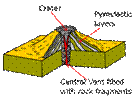
 Strato- or composite-volcanoes are large, steep-sided ‘classic’ volcanoes. These form from alternating eruptions of viscous lava and pyroclasts. Both the pyroclasts and lavas do not carry far from the vent, piling the material up near the vent and producing steep sides. These volcanoes typically erupt explosively.
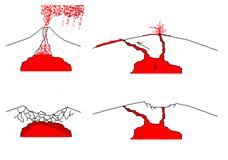 Giant volcanic calderas are the remnants of huge cataclysmic eruptions, the largest eruptions on Earth. The sudden emptying of a large underground magma chambers causes the overlying roof to collapse, producing a circular depression in the ground—the caldera. This depression may sometimes be filled with water (in the case of Crater Lake, Oregon) or even the sea (in the case of Santorini, Greece).
Most volcanoes have several vents, holes through which magma has erupted at various times in the past. Sometimes the vents are aligned, producing rift zones, which appear as ridges extending away from the peak of a volcano.
Craters are like calderas, but much smaller. Some volcanoes have one large central caldera and many smaller satellite craters.
Like earthquakes, floods, and tsunami, the frequency of volcanic eruptions follow a “Gutenberg-Richter’-type relation: small eruptions occur much more frequently than large eruptions.
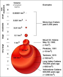 The size of eruptions is quantified with the VEI, “Volcano Explosivity Index” which ranges from 0 to 9. VEI is determined by a combination of eruptive volume and eruptive column height (for explosive eruptions). Explosive eruptions have a larger VEI than effusive eruptions, and are therefore much less frequent.
Worldwide there are always volcanoes with VEI = 0 or 1 erupting. For example, Kilauea volcano on the Island of Hawaii has been in constant eruption for over 20 years. Eruptions with VEI > 6 happen once every century or so, while the largest eruptions with VEI = 8 or 9 occur no more than once every million years or so.
Volcanoes are sometimes classified as active, inactive, or dormant. Dormant is not really a scientific term, as it applies to volcanoes that are active but with a long recurrence interval (and are between eruptions). The only factor that determines whether a volcano is active or inactive is the supply of magma. If magma continues to be formed beneath the volcano, the volcano is active and will erupt at some time in the future. If the supply of magma has been cut off, then the volcano is inactive. For example, the volcanoes on the Hawaiian island of Kauai are inactive because they have moved so far away from the hot spot source of magma that they cannot be resupplied. On the other hand, the volcanoes on the Hawaiian island of Maui are active because, even though they no longer directly overly the hot spot, they are close enough to tap into it and indeed still erupt every 200 years or so.
The average volcanic eruptions last 7 weeks, but this is highly variable. Some are as short as a few hours, and some, like Stromboli in Italy, have been in continuous eruption for about 2,000 years. During any eruption there are phases of intensifying and waning activity.
The style of effusive (lava-producing) eruptions depends on the viscosity of the lava and the amount of volatiles escaping. This in turn depends on the composition of the lava.
Mafic lavas have a low viscosity and usually a low volatile content, and produce effusive eruptions. The initial stages of these eruptions commonly produce fire-fountaining, or spattering. This represents the gas-rich part of the magma escaping.
After lava fountaining, lava pours out of the ground and flows away quietly. These lava flows usually travel meters/day, so that they threaten property not humans, who can easily outrun them. There are some rare, super-low-viscosity lavas in Africa that can travel up to 60 m.p.h., but these are rare.
 Free-flowing lava flows can be further classified as either pahoehoe or aa (Hawaiian terms). Pahoehoe is ropy lava, and forms from the least viscous mafic lava. Aa is composed of jagged, rugged pieces of rock that slowly tumble over each other, and is produced from lava that has lost volatiles and therefore become slightly more viscous.
Intermediate and silicic lavas have a much higher viscosity and do not flow. These only form when the lava is essentially ‘dry’; i.e., devoid of volatiles (which would otherwise trigger an explosive eruption; see below). These oozing lava flows are termed volcanic domes.
Intermediate and silicic magmas that contain dissolved volatiles do not erupt as lava flows, they erupt explosively producing tephra.
These eruptions produce mixtures of hot gas and tephra. The hot gas is less dense than the cooler atmosphere, while the tephra is denser. The kind of explosive eruption depends on the density of the gas/tephra mix relative to the density of the atmosphere.
When the mixture of tephra and hot gas is less dense than the atmosphere, it rises producing an eruptive column. This column may be up to 45 km high (30 miles!), and reach into the stratosphere.
As the mixture rises it cools. Eventually the gas cools to the point that it is no longer less dense than the surrounding atmosphere and the heavy tephra (now cool) falls back to Earth. This rain of tephra is called a pyroclastic fall deposit, and typically consists of lapilli near the vent and extensive deposits of ash farther away.
Pyroclastic fall deposits are cool and therefore do not kill directly. They are heavy, however, and can collapse roofs. The fine ash may get into machinery and destroy it. Ash is a major aviation hazard, and planes must be diverted so as not to suck ash into their engines.
Pyroclastic fall deposits may cover extensive areas. For example, the prehistoric eruption of Mt. Mazama spread ash over an area approximately 50 times as great as the 1980 eruption of Mt. St. Helens.
Pyroclastic fall deposits vary in thickness. They are thickest near the vent, where they can be several meters thick, and taper to a few mm far away from the vent.
When the mixture of tephra and hot gas is denser than the atmosphere pyroclastic surge or pyroclastic flow deposits are created.
Pyroclastic surge deposits form when the mixture is slightly denser than the atmosphere. These mixtures have an extremely low viscosity, which allows them to spread out over the land symmetrically without regard to topography.
Pyroclastic surges can travel up to 500 kph. Because they are tephra-poor, they tend to produce thin deposits, no more than a meter thick.
The most common form of pyroclastic surge is a base surge. This occurs when an eruption column, which is initially less dense than the surrounding atmosphere because it is hot, cools, becomes denser, and then collapses around the vent.
Pyroclastic surges can be very destructive because they travel so fast. They are usually relatively cool (< 300ºC) but very forceful. They can knock down trees and structures, and destroy vehicles.
Pyroclastic flows are the most fearsome of all volcanic events. They occur when a dense mixture of red-hot pyroclasts and gas flows rapidly down the sides of a mountain as a dense gravity flow. Because the mixture is so dense it flows like a river, following valleys and avoiding hills and ridges.
Pyroclastic flows were not discovered until 1902 when a series of devastating pyroclastic flows destroyed the town of St. Pierre on the island of Martinique. They cannot be observed directly because plumes of escaping gases obscure the red-hot flow beneath.
Pyroclastic flows can also travel up to 500 kph and are extremely hot, usually ≈ 1,000 ºC. They can kill by impact, suffocation, or incineration. Because they are so fast there is little time to flee a pyroclastic flow if you are in its way.
Pyroclastic flows are denser than air but less dense than water; therefore they can travel over water. People in ships anchored in harbors have been killed by pyroclastic flows.
Pyroclastic flows sometimes form a distinctive deposit called a welded tuff. After the flow comes to rest the hot gas escapes upward and the hot pyroclasts collapse to the ground. If the pyroclasts consist of glass fragments that are still extremely hot, the glass fragments will weld together into a hard rock. Welded tuffs commonly contain flattened pumice pancakes, formed when hot, soft pumice (glass sponge rock) is compressed in the welded tuff.
Lahars are an important volcanic hazard that may occur days, weeks, or even months after an eruption. They are volcanic mudflows that form when loose tephra mixes with water and forms a slurry with the consistency of wet concrete. This slurry (the lahar) travels like a viscous river at speeds up to 90 kph down valleys and may travel up to 100 km away from the vent. When it stops the slurry solidifies into a material with the consistency of dry cement.
Lahars are most common on stratovolcanoes because: (a) these are often tall mountains covered with ice and snow, which can provide the source of water if melted; and (b) these produce voluminous ash during explosive episodes.
The most dangerous volcano in the United States is Mt. Ranier in Washington state, and it is lahars that pose the greatest risk. Prehistoric lahars have traveled as far as 100 km from the volcano, and lahar deposits are found in Tacoma, a city with over 200,000 people.
Volcanic gases are another volcanic hazard. The principle volcanic gases are H2O and CO2. CO2 is toxic, and heavier than air.
Fumaroles are vents that discharge gas, and they occur on most volcanoes. In many cases they are coated or built up with mineral deposits, in particular sulfur. These minerals precipitate out of the hot gases when they cool.
Volcanic gases are a particular hazard on the Big Island of Hawaii. Gases from Kilauea volcano are blown down wind by the prevailing trade winds, mix with the humid air, and produce a toxic acid rain. This acid rain creates unfavorable growing conditions downwind, and is the origin of the odd “Kau Desert”.
The volcanic gas CO2 was responsible for over 1,800 deaths in Lake Nyos, Cameroon in 1989. CO2 vented into a lake, Lake Nyos, and accumulated near the bottom where it dissolved into the water. When the lake overturned in the spring, the CO2 escaped, flowed over the land and killed people and livestock.
Volcanic eruptions can and have been successfully predicted. Geologists use four primary methods (EDGE):
E is for eruptions, prior and on-going. Ancient eruptions tell geologists how a volcano is likely to erupt in the future (i.e., explosively vs. quietly). An ongoing eruption typically occurs in many phases, and usually the largest phase is preceded by many smaller phases.
For example, the 1991 cataclysmic eruption of Mt. Pinatubo could be foreseen from the previous year’s activity, which included at least 6 minor eruptions.
D is for deformation. Inflation of the magma chamber typically causes distension of the land above, and this distension can be measured.
At Hawaii, the distension is subtle and is measured with sensitive instruments called tiltmeters and by satellite GPS. Slight inflation of the magma chamber can be observed from changes in tilt. This method has been able to forecast up to 25 different eruptive phases of the ongoing eruption at Kilauea.
At Mt. St. Helens the deformation was obvious. A huge bulge appeared on the side of the volcano in March, 1980, and proceeded to expand by over 2 km in two months. Finally, on May 18th, 1980 the volcano exploded.
The cataclysmic eruption occurred when a landslide stripped away much of the cover over the bulge, allowing the magma underneath to explode outwards through the weakened flank. The force was directed horizontally, producing a lateral blast that caught volcanologists off guard.
G is for gases. Gases escaping from the top of a rising column of magma and precede it out of the volcano. Geologists measure changes in the concentration and type of gases to see when the magma is rising. The most important gas used is SO2, which can only be delivered by magma rising from deep inside the Earth.
E is for earthquakes. The slow accumulation of magma under a volcano produces earthquakes, and the rapid ascent of magma during an eruption produces earthquakes too.
Volcanic earthquakes can be distinguished from normal ‘tectonic’ earthquakes by their longer period (longer wavelength, lower frequency). Volcanologists distinguish two types of volcanic earthquakes: Long-period (LP) events, which are discrete vibration events with a long period, and harmonic tremor, which is continuous LP vibration.
LP events and harmonic tremor are thought to be produced by magma pulsing through narrow tunnels and channels as it rises under the volcano.
Volcanic hazards can be mitigated by zoning. For example, geologists have identified hazard zones on the Big Island of Hawaii due to the island’s three active volcanoes. These zones form the basis of zoning regulations designed to keep people and infrastructure out of areas likely to experience volcanic damage.
On the island of Iceland, citizens were able to stop a lava flow threatening their city by spraying it with water. This is the only known example of this technique working.
Lake Nyos, in Cameroon, has been tamed by the addition of a de-gassing system. Bottom waters from the lake are continuously pumped to the surface and sprayed into the air, where they degas. This prevents CO2 from building up in the bottom of the lake, like they did prior to the 1989 disaster.
Volcanic risks in the US occur at: (a) the Pacific Northwest Cascades range; (b) Alaska, especially the Aleutian Islands; (c) Hawaii; and (d) Yellowstone volcano.
The Cascades are formed by subduction and consist of 12 active stratovolcanoes and one shield volcano (Medicine Lake). The most active have been Glacier Peak, Mt. St. Helens, Medicine Lake, and Mt. Shasta.
The 1980 eruption of Mt. St. Helens was the last large eruption in the Cascades. Since that time a resurgent dome has grown within the caldera, producing many earthquakes and smaller eruptions.
The Aleutian Islands are a volcanic arc produced by subduction of an oceanic plate beneath another oceanic plate. They erupt very frequently, and at least three are presently active. Because of the low population density in Alaska, they do not pose as big a threat as Cascade volcanoes to loss of life.
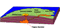
Hawaii is a hotspot volcano that generally erupts effusive mafic lava. Volcanism is presently centered on the Big Island of Hawaii, which contains two active volcanoes—Mauna and Kilauea. Eruptions occur both at the summit and along rift zones, and are largely conveyed downslope to the sea via lava tubes. Holes in lava tubes, where you can see the lava flowing inside, are called skylights.
Mauna Loa erupts on average every 12 years and can threaten Hilo, located 50 km away.
Yellowstone is a hotspot volcano that generally erupts explosively to produce giant calderas. There have been 3 caldera-forming eruptions at Yellowstone, 2.2 m.y., 1.2 m.y., and 600,000 years ago. Yellowstone is presently inflating, though it is not likely that this portends an imminent eruption. A “supereruption” of Yellowstone would devastate much of the American west, would cause global ashfall, and would produce a ‘volcanic winter’ due to the injection of so ash into the stratosphere (which blocks the arrival of sunlight).
Source : http://spot.pcc.edu/~aodman/GS106/volcanoes.doc
Web site link: http://spot.pcc.edu/~aodman
Google key word : Volcanoes and Other Igneous Activity summary file type : doc
Author : not indicated on the source document of the above text
If you are the author of the text above and you not agree to share your knowledge for teaching, research, scholarship (for fair use as indicated in the United States copyrigh low) please send us an e-mail and we will remove your text quickly.
Volcanoes and Other Igneous Activity summary
· The primary factors that determine the nature of volcanic eruptions include the magma's composition, its temperature, and the amount of dissolved gases it contains. As lava cools, it begins to congeal, and, as viscosity increases, its mobility decreases. The viscosity of magma is directly related to its silica content. Granitic (felsic) lava, with its high silica content (over 70 percent), is very viscous and forms short, thick flows. Basaltic (mafic) lava, with a lower silica content (about 50 percent), is more fluid and may travel a long distance before congealing. Dissolved gases tend to increase the fluidity of magma and, as they expand, provide the force that propels molten rock from the vent of a volcano.
· The materials associated with a volcanic eruption include (1) lava flows (pahoehoe flows, which resemble twisted braids, and aa flows, consisting of rough jagged blocks; both form from basaltic lavas); (2) gases (primarily water vapor); and (3) pyroclastic material (pulverized rock and lava fragments blown from the volcano's vent, which include ash, pumice, lapilli, cinders, blocks, and bombs.)
· Successive eruptions of lava from a central vent result in a mountainous accumulation of material known as a volcano. Located at the summit of many volcanoes is a steep-walled depression called a crater. Shield cones are broad, slightly domed volcanoes built primarily of fluid, basaltic lava. Cinder cones have very steep slopes composed of pyroclastic material. Composite cones, or stratovolcanoes, are large, nearly symmetrical structures built of interbedded lavas and pyroclastic deposits. Composite cones produce some of the most violent volcanic activity. Often associated with a violent eruption is a nuée ardente, a fiery cloud of hot gases infused with incandescent ash that race down steep volcanic slopes. Large composite cones may also generate a type of mudflow known as a lahar.
· Most volcanoes are fed by conduits, also called pipes. As erosion progresses, the rock occupying the pipe is often more resistant and may remain standing above the surrounding terrain as a volcanic neck. The summits of some volcanoes have large, nearly circular depressions that exceed 1 kilometer in diameter called calderas. Although volcanic eruptions from a central vent are the most familiar, by far the largest amounts of volcanic material are extruded from cracks in the crust called fissures. The term flood basalts describes the fluid, water-like, basaltic lava flows that cover an extensive region in the northwestern United States known as the Columbia Plateau. When silica-rich magma is extruded, pyroclastic flows consisting largely of ash and pumice fragments usually result.
· Intrusive igneous bodies are classified according to their shape and by their orientation with respect to the host rock, generally sedimentary rock. The two general shapes are tabular (sheetlike) and massive. Intrusive igneous bodies that cut across existing sedimentary beds are said to be discordant; those that form parallel to existing sedimentary beds are concordant.
· Dikes are tabular, discordant igneous bodies produced when magma is injected into fractures that cut across rock layers. Tabular, concordant bodies, called sills, form when magma is injected along the bedding surfaces of sedimentary rocks. In many respects sills closely resemble buried lava flows. Laccoliths are similar to sills but form from less-fluid magma that collects as a lens-shaped mass that arches the overlying strata upward. Batholiths, the largest intrusive igneous bodies with surface exposures of more than 100 square kilometers (40 square miles), frequently make up the cores of mountains.
· Most active volcanoes are associated with plate boundaries. Active areas of volcanism are found along the oceanic ridges (spreading center volcanism), adjacent to ocean trenches (subduction-zone volcanism), as well as the interiors of plates themselves (intraplate volcanism).
Chapter Outline
I. Volcanic eruptions
A. Factors that determine the violence of an eruption
1. Composition of the magma
2. Temperature of the magma
3. Dissolved gases in the magma
B. Viscosity of magma
1. Viscosity is a measure of a
material's resistance to flow
2. Factors affecting viscosity
a. Temperature (hotter magmas are less viscous)
b. Composition (silica content)
1. High silica = high viscosity (e.g. felsic lava)
2. Low silica = more fluid (e.g., mafic lava)
c. Dissolved gases
- Gas content affects magma mobility
2. Gases expand near the surface and extrude lava
3. Violence of an eruption is related to how easily gases escape from magma
- Fluid basaltic lavas are generally quiescent
- .Highly viscous magmas produce explosive eruptions
II. Materials extruded during an eruption
A. Lava flows
1. Basaltic lavas are more fluid
2. Types of basaltic lava
a. Pahoehoe lava (resembles braids in ropes)
b. Aa lava (rough, jagged blocks)
B. Gases
1. One to 6 percent of magma by weight
2. Mainly water vapor and carbon dioxide
Volcanoes and Other Igneous Activity
C. Pyroclastic materials
1. "Fire fragments"
2. Types of pyroclastic material
a. Ash and dust - fine, glassy fragments
b. Pumice - from "frothy" lava
c. Lapilli - "walnut" size
d. Cinders - "pea-sized"
e. Particles larger than lapilli
1. Blocks - hardened lava
2. Bombs - ejected as hot lava
III. Volcanoes
A. General features
1. Opening at summit
a. Crater (steep-walled depression at the summit)
b. Caldera (a summit depression greater than 1 km diameter)
2. Vent (connected to the magma chamber via a pipe)
B. Types of volcanoes
1. Shield volcano
a. Broad, slightly domed
b. Primarily made of basaltic (fluid) lava
c. Generally large
d. Generally produce a large volume of lava
e. e.g. Mauna Loa in Hawaii
2. Cinder cone
a. Built from ejected lava fragments
b. Steep slope angle
c. Rather small size
d. Frequently occur in groups
3. Composite cone (or stratovolcano)
a. Most are adjacent to the Pacific Ocean (e.g., Fujiyama, Mt. Shasta)
b. Large size
c. Interbedded lavas and pyroclastics
d. Most violent type of activity (e.g. Vesuvius)
e. Often produce nuée ardente
1. Fiery pyroclastic flow made of hot gases infused with ash
2. Flows down sides of a volcano at speeds up to 200 km per hour
f. May produce a lahar, a type of volcanic mudflow
IV. Other volcanic landforms
A. Calderas
1. Steep walled depression at the summit
2. Size exceeds one kilometer in diameter
3. Types of calderas
- Crater Lake-type
- Hawaiian-type
- Yellowstone-type
B. Fissure eruptions and lava plateaus
1. Fluid basaltic lava extruded from crustal fractures called fissures
2. Produces flood basalts
3. e.g., Columbia Plateau
C. Volcanic pipes and necks
1. Pipes are short conduits that connect a magma chamber to the surface
2. Volcanic necks (e.g., Ship Rock, New Mexico) are resistant vents left standing after erosion has removed the volcanic cone
V. Intrusive igneous activity
A. Most magma is emplaced at depth
B. An underground igneous body is called a pluton
C. Plutons are classified according to
1. Shape
a. Tabular (sheetlike)
b. Massive
2. Orientation with respect to the host (surrounding) rock
a. Discordant - cuts across sedimentary beds
b. Concordant - parallel to sedimentary beds
D. Types of igneous intrusive features
1. Dike, a tabular, discordant pluton
2. Sill, a tabular, concordant pluton (e.g., Palisades Sill, NY)
3. Laccolith
a. Similar to a sill
b. Lens shaped mass
c. Arches overlying strata upward
4. Batholith
a. Largest intrusive body
b. Surface exposure 100+ square kilometers (smaller bodies are termed stocks)
c. Frequently form the cores of mountains
VI. Plate tectonics and igneous activity
A. Global distribution of igneous activity is not random
1. Most volcanoes are located along the margins of ocean basins
2. Other general locations include
- Deep ocean basins
- Interiors of the continents
3. Plate motions provide the mechanism by which mantle rocks melt to generate magma
- Igneous activity at convergent plate boundaries
1. Oceanic crust descends into the mantle, generating an oceanic trench
2. Descending plate partially melts
3. Magma slowly rises upward
4. Rising magma can form
a. Volcanic island arc in an ocean
b. Andesitic to granitic volcanoes in a continental volcanic arc
5. Most of the activity is associated with the rim of the Pacific Basin, called the "Ring of Fire"
C. Igneous activity at divergent plate boundaries
1. The greatest volume of magma is produced along the oceanic ridge system
a. Lithosphere pulls apart
b. Less confining pressure on underlying rocks
c. Partial melting of mantle rock occurs
- d. Large quantities of basaltic magma are produced
2. Not all spreading centers are located along the axis of an oceanic ridge
D. Intraplate igneous activity
- Activity within a rigid plate
2. Plumes of hot mantle material ascend toward the surface
a. Form localized volcanic regions called hot spots
b. Associated with the Hawaiian Islands
Source : http://spot.pcc.edu/~aodman/GS106/volcanoes.doc
Web site link: http://spot.pcc.edu/~aodman
Google key word : Volcanoes and Other Igneous Activity summary file type : doc
Author : not indicated on the source document of the above text
If you are the author of the text above and you not agree to share your knowledge for teaching, research, scholarship (for fair use as indicated in the United States copyrigh low) please send us an e-mail and we will remove your text quickly.
Volcanoes and Other Igneous Activity summary
If you want to quickly find the pages about a particular topic as Volcanoes and Other Igneous Activity summary use the following search engine:
Volcanoes and Other Igneous Activity summary
Please visit our home page
Larapedia.com Terms of service and privacy page